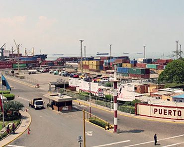
It is a port located west of the Maracaibo Bar Channel, about 55 kilometers (30 miles) south of Zapara Island, with a surface area of 99,000 m². The port has a set of cylindrical silos with 24 and 18 intersilos with a total capacity of approximately 30,000 tons. It handles general cargo and bulk, with a total of 1.321 million tons per year. It has a warehouse and yards for general cargo, with an area of approximately 14,700 m². The Maracaibo Bar Channel was dredged in 1958 and currently has a depth of 14 meters (45 feet), referring to low water spring tide (LWS), and is maintained through periodic dredging. To take advantage of the maximum draft, vessels leaving the bar must cross two (2) hours before or after high tide.
Puerto Internacional de Maracaibo
Ubicación geográfica
Dimensiones: 107 Hectares
Área del puerto: 99,000 m²
Patios comerciales 11
Latitud: 10° 38′ 01″ North (N)
Longitud: 071° 36′ West (W)
Instalaciones portuarias
| Embarcadero | Borrador | Longitud | Remolcadores |
|---|---|---|---|
| 8 | 8.70 m | 190 m | 2 o 3 Wp |
| 9 | 9.60 m | 192 m | 2 o 3 Wp |
Observaciones: The maximum length is 192 m, but if required, there is the possibility of receiving ships over 200 meters in length as both docks would be used. Docks 8 and 9 are regularly used every 12 days by container ships.